Burgess model or concentric zone model – urban land use model
Ernest Burgess gave a model to define how different social groups are located in a metropolitan area. Social groups based on the socio-economic status of households and distance from central area or downtown. This model is known as the concentric zone model because the different locations were defined in the form of rings around the core urban area around which city grew. Burgess Model is another name for this model (given after the name of Ernest Burgess). Concentric Zone Model or CCD model was developed between 1925 and 1929 based on the study of American cities. Chicago city was studied for which Burgess provided empirical evidence. This was one of the many models studied under settlement geography such as Hoyt Model or Sector Model
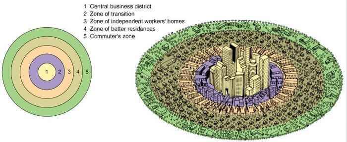
Different zone in the Burgess Model or Concentric Zone Model
Various researchers and scholars have debated over the number of zones in the Burgess concentric zone model. Some consider them to be five whereas some consider 6 zones to explain this urban land use model. The center is the oldest part of the city around which the city expands over time, and the newest development comes on the edges. Some people also refer this model as concentric circle theory because of the arrangements in form of circles.
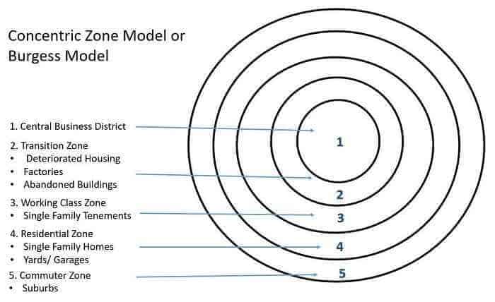
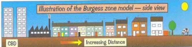
Zone I (Central Business District) – This is the center (innermost zone) where the central business district is located and has highest land value. The zone has tertiary activities and earns maximum economic returns. Another feature is the accessibility of the area because of the convergence and passing of transport networks through this part from surrounding and even far places in the city. This part has tall buildings and noticeably high density to maximize the returns from land. Commercial activity taking place in the area results in negligible residential activity in this zone.
Zone II (Transition Zone) – The mixed residential and commercial use characterizes this zone. This is located adjacent and around the CBD and is continuously changing, i.e. transition takes place. Another feature is the range of activities taking place like mixed land use, car parking, cafe, old buildings. This zone of transition is considered to “decay” because of a large number of old structures as the buildings in transition zone were earlier used for factories and tenement housing blocks. This zone had a high population density when industrial activities were at their peak. Those residing in this zone were of the poorest segment and had the lowest housing condition.
Zone III (Inner City/ Working Class zone) – This area is occupied for residential purpose and also known as “inner city” or “inner suburbs.” It consisted of houses built to accommodate factory workers but had better condition than the transition zone. This area has a mix of new and old development and generally requires orderly redevelopment. People living in this zone are second generation immigrants as many moves out of the transition zone to this zone whenever affordable. This zone is nearest to the working area with modest living conditions, and this resulted in reduced commuting cost. Another interesting feature includes the large rental housing occupied by single workers.
Zone IV (Outer Suburbs/ White Collar Homes) – This zone had bigger houses and new development occupied by the middle class. Many of the homes are detached, and unlike single occupants of inner suburbs, families resided in these homes. Better facilities are available to the residents like parks, open spaces, shops, large gardens but this comes at an increased commuting cost.
Zone V (Commuter Zone) – This is the peripheral area and farthest from the CBD, this resulted in highest commuting cost when compared with other zones. Significant commuting cost gave the name “commuter zone” to this part. People living in this part were high-income groups which could afford large houses, could pay commuting charges, had access to different transportation mode, enjoy modern facilities like shopping malls. Low rise development, large gardens, less population density are some of the characteristics of this zone.
The rationale behind Concentric zone theory
The Burgess model takes into account the positive correlation between economic status and distance from downtown. This is sometimes also referred to as concentric zone model or simply concentric model or concentric theory. This considers, better the economic status more the distance from the central area. The central area has high density, and the availability of land is scarce. Because of this more affluent segment of the society reside away from the city center where they can build large houses. Burgess described the changing spatial patterns of residential areas as a process of “invasion” and “succession”. As the city grew and developed over time, the CBD would exert pressure on the surrounding zone (the zone of transition). Outward expansion of the CBD would invade nearby residential neighborhoods causing them to expand outward. The process continues with each successive neighborhood moving further from the CBD. His work included the study of bid rent curves according to which the land with the highest rent was occupied with economic activities of highest returns. Zone of transitions are important part of the burgess model as they are very active and change of people & activities takes place constantly.
Limitations and Criticisms of Concentric zone model
Concentric zone model is one of the simplest model available. This model accounts for the economic forces which drive development and the study of patterns present at the time of the study. But with the evolution and passage of time urban areas grew more complex and this model cannot define the development of existing cities. Some of the limitations and criticism include:
- Although widely appreciated in the United States Burgess model is not applicable outside the US. This is so, as the pattern of growth is different because of various circumstances.
- The relevance of this model decreased over time. With the advancement in the mode of transportation, mass transit vehicles, motor vehicles, cars changed the way people commute. Accordingly, their preference for living in a particular zone changed.
- It does not take into account the effect of political forces and the restrictions imposed by the government for the improvement of living conditions.
- In reality, no distinct zones and boundaries exist as overlapping of areas is possible in every town. The preference of people changes over time depending on the importance they associate for a particular benefit.
- This model is not applicable to polycentric cities as many CDB exists in such towns. Moreover, every city is different, and the factors influencing the growth of a city are diverse.
https://planningtank.com/settlement-geography/burgess-model-or-concentric-zone-model