The Downtown Brooklyn Partnership wants to make bold streetscape improvements akin to the recent redesign of 14th Street in Manhattan
While parts of Brooklyn are famous for their human scale and walkability, the borough’s downtown is not among them. Much of its street design dates back to the Robert Moses era: Broad arterial roads move cars swiftly to the Brooklyn and Manhattan bridges, public plazas can feel bleak and unsafe, and the collision of three different street grids makes wayfinding difficult.
Yet the neighborhood is one of the fastest growing in New York City. Its population increased 31 percent between 2010 and 2016; the number of jobs also increased between 2010 and 2015, by 26 percent. The neighborhood’s population is expected to double over the next decade.
A new plan by the Downtown Brooklyn Partnership—a consortium of three business improvement districts—seeks to make room for all of those people by curtailing car access and installing protected bike lanes, colorful street furniture, and monumental gathering spaces. “The action plan seeks to re-knit, at a pedestrian and bike scale, many of the streets that were widened or cut off,” said Claire Weisz of the architecture and urban design firm WXY, which produced the plan in collaboration with the Bjarke Ingels Group (BIG).
Revealed exclusively to CityLab, the Downtown Brooklyn Public Realm Vision borrows a number of concepts and features from New York City’s recent street redesigns, including the 14th Street transitway and the pedestrianization of Times Square. The difference is the scope: This plan seeks to reinvent an entire neighborhood, complete with quiet back alleys, bustling intersections, and public-private spaces in new developments. It’s still preliminary—a starting point for reimagining an urban district whose streets have long been dominated by cars.
Downtown Brooklyn is roughly bounded by Atlantic Avenue to the south, Ashland Place to the east, Tillary Place to the north, and Court Street to the west. There are already previews of the changes proposed for the rest of the neighborhood in recently pedestrianized streets surrounding MetroTech Center and Albee Square, and the shared section of Willoughby Street.
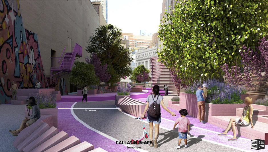
The first phase of the plan would link those pedestrian oases via shared streets, known in the Netherlands as woonerfs, where curbs would be eliminated to make room for landscaping and street furniture. A 15-foot-wide winding traffic lane would be retained in these streets, although vehicle speeds would be severely restricted.
The second phase would extend the shared streets through much of the neighborhood, expand sidewalks along Fulton and Livingston Streets and Boerum Place, and add improved pedestrian crossings along Flatbush Avenue.
All of that space reclaimed from cars would make room for some serious greenery. The plan calls for 950 new trees to add to the existing 1,500 in the neighborhood, and a 230 percent increase in permeable surfaces. Planters will do triple duty, not only as homes for trees but also as benches and as barriers protecting people from cars.
Cyclists would get new protected lanes along Boerum Place, Schermerhorn Street, and Fulton Street. To make room for bike lanes and expanded sidewalks on the Fulton Mall—a corridor that sees higher peak-hour pedestrian traffic than Wall Street—eastbound buses would be diverted one block south to Livingston Street.
The designers emphasize that the plan is intended to help businesses thrive along the busy retail corridor. “You have the opportunity to create places where people want to hang out while they shop,” Weisz said.
The intimidating, complicated intersection of Flatbush and Atlantic Avenues, bounded by an NBA arena and a shopping complex, would become a Shibuya-style multidirectional pedestrian crossing, marked by colorful pavement and maybe even a suspended art installation. The plan also calls for major revamps of Columbus Park next to Borough Hall and University Place.
Many of the streetscapes in question are adjacent to future development sites, and most of the proposed changes will require the approval of the city’s transportation, parks, and planning departments. The Downtown Brooklyn Partnership has started advocating for public funds for key projects, a spokesperson said, adding that the three BIDs could support initiatives within their boundaries, and stakeholders such as property owners might fund improvements on a case-by-case basis. But the partnership could use its own funds to turn some alleys into shared streets as soon as next year, said Regina Myer, its president.
Recent events across the East River could make the larger transformation more feasible. “The city’s transportation department has had this massive success changing the balance of cars and pedestrians and buses on 14th Street in Manhattan,” Myer said. “We want to use that opportunity to do something really bold in downtown Brooklyn.”